After a cold first couple weeks of December, temps have warmed up into the mid 20's, and look to remain in the upper teens/mid 20's range for the next few days. A small, fast moving system, also called an "Alberta Clipper" looks to bring some light snow to the area on Sunday into Monday. I think that areas south and east of the Twin Cities (pretty much the southeastern corner of the state) will see the best chance at some minor accumulations, but really a trace to 2 inches seems likely for most of the area.
As mentioned before, temps look to stay somewhat seasonal for the next couple days, but the end of the week is looking quite interesting. For the past couple days, the models have been showing a large area of low pressure forming in the southern US, then moving NE towards the area. If this thing pans out the way it is being shown now, this would be a very significant winter storm for the plains, including parts of Minnesota and Wisconsin. The forecast models haven't come to an agreement yet on the placement/strength of it, with the GFS being the most sporadic of the models, and the European (ECMWF) being the most consistent. In fact, the National Weather Service said that if the consistent European model pans out, some areas could see a foot or more of snow by Christmas morning. It is something to watch of the next couple days. Like last time, winds will be an issue as the low passes, so the potential is there for a snowy, blustery Christmas. Below is the European's placement of the low Christmas morning.
Saturday, December 19, 2009
Sunday, December 13, 2009
Snow accumulations on the way
After a couple days break from our last winter storm, it appears that our next snow maker is on its way. Radar image below at around 5:30pm already shows snow developing out to our west. HPC still has our area in a low risk of 4 inch snows, with a slightly higher risk just to the north of Eau Claire. Areas circled in blue are low risk (10%), green are moderate risk (40%), and red are high (70%). 18z GFS shows close to .3 inches of liquid, and higher snow ratios (close to 15:1) would put out around 4.5 inches of snow. However, snow may be slow to reach the ground with some drier air in place, so I think totals around 4 inches is possible...with 3-5 around the area. Winter Weather Advisories will remain in effect through the night tonight, and into the first part of our Monday. Areas shaded in purple are under the advisory. Cold air looks to be behind this system, so single digit highs are likely on Wednesday. Temps moderate again towards the end of the week, before perhaps another shot of cold air makes it down from Canada. Let the roller coaster ride continue.
Busy week of weather...snowy Monday?
Wow...what a crazy week it has been. The storm that was advertised by the forecast models for several day, and was mentioned in my previous post, actually came through pretty much as planned. This was a powerful winter storm that affected a very large portion of the United States, with the most significant impact in the higher terrain Colorado, northern Kansas, south central and southeast Minnesota, and pretty much all of Iowa and Wisconsin. The system came ashore in Southern California, trekked east through the four corners region then southeast through the Texas panhandle to eastern Oklahoma, before making a hook towards the northeast through eastern Illinois, to the southern tip of Lake Michigan, before exiting up into Canada. Systems that take this particular track are typically known as a "Panhandle Hooker" or "Texas Panhandler" due to their origination in the Texas Panhandle, then a sharp turn or "hook" towards the northeast. Think of these systems as a giant bucket, scooping up a lot of moisture from the Gulf of Mexico, and carrying it north. That is exactly what this system did, and was truly a classic winter storm. There was plenty of moisture, and plenty of cold air for it to be all snow. Below are three sets of maps. The top one shows the approximate path the storm took along with snow totals. The middle one is also snow totals, but with a closer look into the area. The bottom one is the low track, along with the millibar numbers. This system bottomed out at 976mb, which is quite impressive.
Snow was not the only issue with this system. Strong winds behind it whipped up the very light, fluffy snow, creating blizzard conditions across a large part of southern Minnesota and western Wisconsin. The highest gust reported was in Blue Earth, MN with a gust of 54mph. The winds also created very cold wind chills, as well as drifting snow, which made measurements difficult. The highest amount reported to the NWS in Chanhassen, MN was 13.3 inches in Zumbrota, MN in Goodhue Co., with Eau Claire, WI coming in a close second with 13.1 inches reported. Below is an animation of the storm, from start to finish. You can see how far north the precip made it, even when the center of the storm was well down to the south, and then see it as it deepens (strengthens) as it moves northeast. A typical sign of a storm strengthening is the isobars around the low tighten up, and create almost a spider web look to them.
Now, onto the next system that looks to affect central/southern Minnesota and west central Wisconsin. A low pressure system looks to come ashore in northern California, dip south towards Colorado (named a Colorado Low), then head north east towards Chicago. A band of accumulating snow appears likely over the areas mentioned above, with 2-4..perhaps even 5 inches of snow possible, if rain:snow ratios can get to be high enough, or if a bit more moisture can be tapped from the Gulf. In fact, even as I was putting this blog together, the National Weather Service issued a Winter Weather Advisory for pretty much the entire area Chanhassen covers, as well as a small portion that La Crosse covers. The counties in the advisory are shaded below. Expect the snow to begin late Sunday night, and last through the night into Monday morning. Many should expect a slow commute back to work on Monday. The HPC also highlighted an area, also shown in the map below, that has a low risk (10%) of seeing 4 or more inches of snow. It is the area that is to the south of the northern line, and to the north of the southern line (I hope that makes sense). If you're not a fan of the snow or cold, well, sorry. The snow looks to be around up through Christmas, as well as do the colder temps.
Friday, December 4, 2009
Colder air invades...potential Winter Storm next week
After a below normal October and above normal November, temps have, once again, dropped below normal numbers for our first week of December, and it doesn't appear the cold air is going anywhere anytime soon. In fact, long range models showing an even colder air mass heading our way for the end of next week. That cold air will help to stir up what appears to be the first significant snowfall of the season. Exactly where the snow will fall, and how much will fall is still way up in the air, but both the GFS and European models show this potent low, with the Euro being the stronger of the two. European models have great track records during winter months, and the GFS is coming into alignment with it. Some things in our favor...the cold air is here, and this system looks plenty cold. Surface temps will have a good week to cool off, so the snow shouldn't have a problem sticking. The models have also trended a bit north from where they were yesterday, bringing the low up close to Chicago, rather than across southern IL. If this system can nudge a bit further north and west, and track over Madison, then we would be in business. However, even now, accumulating snow looks possible. I think the kicker with this storm will be the timing of the very cold air mass behind it, with the low riding up the leading front. If the front moves slower, it should push the track further west. Faster movement means it would just shove the whole thing too far east, so there's still much to watch. Some other interesting facts about these systems...they are good wind makers, so even a little bit of snow, along with the wind can create very hazardous travel. Add a chill in the air, and you've got winter in Wisconsin. Second, snow ratios increase as the system progresses. The colder the temps are, the higher the ratio..so it could very easily start out around 13:1 snow:rain, and end up at 20-25:1 ratio. Higher snow ratios means it would take less liquid to accumulate snow, and the more powdery the snow is. (Example: .25 inches of liquid, 10:1 ratio would be 2.5 inches of snow...15:1 would be 3.75...25:1 would be 6.25 inches of snow...and so on.) Not great for snowman making, but simple to clear off a sidewalk or car. There are some downsides too, for those who like snow. Stronger systems can draw drier air into them, pretty much killing off any precip more quickly than expected. Also, if there's any strong/severe weather between here and the Gulf, then the potential is there for those storms to rob the moisture trying to make it up here. The good thing is that it looks like it will start far enough south that it will be able to draw the moisture down there and carry it north. Either way, this system will be closely watched, as many model runs are between now and Tuesday. In the shorter term, some accumulating snow is possible for southwest WI for the end of this weekend, mostly south of the I-90 corridor. COME ON SNOW!!
Thursday, October 22, 2009
Temps remain cool...maybe some flakes on the way
Our below average temps continue, and appear to have no signs of going away. Temperatures appear to be staying in the upper 30's and lower 40's through the next few days, with perhaps some snow coming into play on Friday. The HPC currently has the area in a slight risk (10%) of seeing 4 inches of snow on Friday, although surface temps still appear to be much too warm to really support this. I guess we'll see. Next week, models are advertising a potent storm system around the Wednesday time frame. However, the models are not agreeing on the track of the storm, with the ECMWF taking the low much further to the west than the GFS, leaving eastern MN and western WI in the warm sector of the storm. The GFS, however, takes it up through central WI, leaving us in a much more favorable area for snow, if temps cool enough. While this is still a ways out, it appears as though the first big winter storm of the season could be on the way for the Upper Midwest. Where in the Upper Midwest, however, is anyone's guess!
Sunday, October 18, 2009
Warmer start to the week...Soaker on the way?
After being well below normal for quite some time, some warmer temps are moving into the state. Sunday sounds like it's going to be the nicest day with highs in the mid to upper 50's across Eastern MN and Western WI, low 60's across Western MN, and even possibly some 70 degree temps across Southwest MN. Here's some facts about the month of October so far from the National Weather Service: A RECORD COLD...WET AND SNOWY TWO WEEKS IN OCTOBER FOR THE TWIN CITIES.
THE NORMAL HIGH TEMPERATURE FOR THE FIRST 2 WEEKS IN OCTOBER IS 63.
THIS YEAR THE HIGH TEMPERATURE WAS 47 DEGREES.
THAT IS THE COLDEST FIRST 2 WEEKS OF OCTOBER ON RECORD.
THE PREVIOUS COLDEST WAS 52 DEGREES IN 1875.
THE MOST RECENT COLD WAS 54 DEGREES IN 1979.
THE NORMAL LOW TEMPERATURE FOR THE FIRST 2 WEEKS IN OCTOBER IS 42.
THIS YEAR THE LOW TEMPERATURE WAS 36 DEGREES.
THAT IS NUMBER 10 COLDEST. TIED WITH 1985...1987...AND 1993.
IT WAS IN THE TOP TEN WETTEST.
SO FAR IT IS THE 7TH SNOWIEST FULL OCTOBER.
THE SNOWIEST OCTOBER IS...1991 HALLOWEEN SNOW STORM...WITH 8.2 INCHES.
MISERY LOVES COMPANY...THE TWIN CITIES IS NOT STANDING ALONE IN THE
COLD RAIN.
ST CLOUD MINNESOTA AND EAU CLAIRE WISCONSIN SHARED THE RECORD COLDEST
HIGH TEMPS.
A mid week soaking appears to be on the way for Minnesota and Wisconsin, with both the GFS and ECMWF showing a potent low moving through the area. The ECMWF takes the low up through South Central MN, then northeast towards the U.P. of Michigan. The GFS is further east, taking the low up through Southwest Wisconsin, then lingering in the area before moving off to the northeast. Canadian models are further west, having the low enter Southwest MN, then moving it east and a little north to have it move right over the Twin Cities. All of the models show this warm enough to be all rain. If this were winter time, we would be looking at a large winter storm over the area. However, this won't be the case, due to the warm temps at pretty much all layers of the atmosphere. It looks to be a wind maker as well, with all of the models showing the low winding up pretty good. Early early guestimates for rainfall looks like it could be anywhere between 1-3 inches, but that is early and will likely change with each run. Until then enjoy the next couple days, because colder air will fill in, once again, behind the approaching mid week storm system. Below are forecast models from ECMWF (Top), GFS (Middle) and Canadian (Bottom), at 7pm on Thursday.
Tuesday, October 13, 2009
Snow leaves...cold doesn't (yet)
The first accumulating snowfall of the season brought some decent snowfall to the area, but most places you wouldn't know it due to the fact that we were above freezing through most of the day. Therefore, most of it has already melted, which is somewhat of a concern overnight. Temps will drop well below freezing, so untreated roads, sidewalks, overpasses (etc) could become slippery in spots. The final snow amounts have yet to be posted, but generally they range from just over half an inch (Milaca, MN), to as high as just over 4 inches of snow (U of M, St. Paul campus).
Temps will stay cool through the week, with some warming coming for the weekend (mid to upper 50's?) Those warmer temps will probably only last a few days, as long range shows another cool down. If this were spring, things would be trending upwards in the temperature department, but unfortunately, it's downhill from here. Until then, things will stay unsettled with chances of rain/snow right up to the weekend, but temps will stay warm enough that if there's any accumulations, it will be minor, and melt right away.
Sunday, October 11, 2009
Winter Storm Watch cancelled...Winter Weather Advisory issued
As previously thought, the National Weather Service has canceled the Winter Storm Watch, and issued a Winter Weather Advisory to the southeast of where the watch previously was. As discussed before, models have been shifting the heavier precip south, and there is now enough consistency for them to drop the watch and issue the advisory. Below is a map of the current advisory, which goes into effect at midnight tonight, and runs until 4pm on Monday. Counties included in this advisory are Blue Earth, Brown, Carver, Dakota, Faribault, Freeborn, Goodhue, Hennepin, Le Sueur, Martin, McLeod, Nicollet, Ramsey, Redwood, Renville, Rice, Scott, Sibley, Steele, Waseca, Washington, Watonwan [MN] and Pierce, St. Croix [WI]. You can also see some snow starting to show up on radar in SW Minnesota.
As far as snow totals, I think the NWS actually has a decent handle on their estimates. Below is a map (courtesy NWS Chanhassen, MN) of snowfall predictions for the area.
Quick update on early season winter storm
Just a quick little update from my blog post from earlier. The NWS is beginning to fall more in line with the HPC, now saying that the heavier snow looks to fall just south of the current watch area. Current headlines will stay as is for now, and will be re-evaluated by the day crew, just in case things happen to shift a bit north again, although according to the NWS, this is unlikely. Even though there is a Winter Storm Watch up, I would be surprised to see it go to a warning, mostly because I really don't think that widespread totals will be enough to warrant a warning. Instead, my gut is telling me that they will go with a Winter Weather Advisory for most of central MN, parts of southern MN, and over to western WI, where between 2 and 5 inches could fall. The only reason I could see them issuing a warning for this is because the snow could very well fall during busy travel times on Monday, and it is the first large snow potential of the season. Check back for future updates on this approaching system.
Saturday, October 10, 2009
First Winter Storm of the season
Well, we've been talking about it for a while now, and everything still appears to be on course. The first winter storm of the season will be developing in the Rockies, then head up in this direction, bringing with it snow where it's cold enough, and a mix where it's warm enough. First, the National Weather Service in the Twin Cities has issued a Winter Storm Watch for portions of central MN, effective from midnight Monday, until 4pm Monday. Below is a map of where the watch is in effect.
Estimated accumulations are still a bit of a problem. As mentioned previously, warm ground, timing and speed of the system, and the amount of mixing that goes on in the storm, all play crucial roles in how much snow we get. The two maps below show the HPC forecast (top), and the National Weather Service's forecast (bottom) for snow estimates. The NWS favors more north, where the HPC favors more south. Either way, the first "significant" snow of the season still appears to be on the way. Stay tuned for any further watches, warnings, or advisories that may be issued.
Snow falling in Wisconsin/Minnesota
The cold front, and snow that is coming with it, has crossed over into Wisconsin early this morning. Snow has been reported across parts of Minnesota, leaving a nice little dusting on any cars or trucks that were left outside. Below is a radar image from 3:17am on Saturday morning. You can see the line of snow, as well as the approx. position of the cold front. The line of snow should continue to move off to the east through the late night/early morning hours.
Stronger storm system still on track for Sunday into Monday, but there are still uncertainties as to how this system will evolve. In fact, there will probably still be a lot of unknowns right up until the storm actually gets here. Below is the latest update from the HPC in regards to the probability of seeing at least 4 inches of snow from the system.
Also, according to the National Weather Service office in Chanhassen, some 2-4 inch amounts are possible with this system. Models are beginning to align, but aren't all on the same page quite yet. Below is a map of their first estimates on how much snow will fall. These are very early predictions, and will likely change, and hopefully they will be narrowed down even more as time goes on.
Friday, October 9, 2009
Quick snow update...perhaps larger system on the way?
The first snowfall of the season has officially arrived in MN, ahead of schedule. The snow line was supposed to be in Western Wisconsin around the noon hour on Saturday, but the front has decided to increase in speed, putting the snow band in Western WI around the 2am time frame. Below is a radar image of where the snow is, as of 11:20pm on Friday night, as well as the cold front position, and the current Freeze Warnings for SE MN and SW WI.
A much larger system appears to be on the way to Minnesota and Wisconsin on Sunday, bringing a mix of rain and snow to the area. There are still many uncertainties with this system, including exactly where the rain/snow line will line up, how far north the low will travel, and how much snow will be able to accumulate with the ground not yet frozen. At this point, the HPC is forecasting a pretty good chance of accumulating snows across Minnesota, with the highest likely hood being to areas north and west of the Twin Cities. Below is a graphic of the likely hood of seeing at least 4 inches of snow from the system. Areas shaded in blue are a slight risk (10%), green a moderate risk (40%), and red a high risk (70%) of receiving at least 4 inches of snow. Lots still up in the air, and a lot will likely change, but stay tuned!
Turning colder...snow still on track
For those people looking for 80 degrees, humidity, and all of that stuff that comes with summer, well, you'll have to wait about 8 months before we see it again. The cold air mass is headed from towards the MN/WI area from Canada, bringing with it the start of some much colder temperatures, and the end of the growing season. Freeze Warnings are currently in effect for Western MN, and parts of Central MN. Areas up in NE MN are not in the warning, likely because they have already seen a hard freeze, officially ending their growing season. This whole air mass will be over the eastern part of MN and Western WI beginning Friday night and lasting right up into next week. As long as skies clear enough, and winds die down enough, Freeze Warnings will likely be needed for the rest of us in Eastern MN and Western WI. Below is a map with the current warnings, as well as showing the approx. freezing line as of 3:35am Friday.
The first snowfall of the season still appears to be on track for overnight Friday, but more likely Saturday morning. According to the 00z run of the WRF, the band of snow should be approaching the MN/WI border around the 7am time frame, but that will likely be adjusted with each run. Up to an inch of snow could fall on grassy areas, mostly because the roads are simply too warm for anything to accumulate on them. The snow should melt through the day as temps get above freezing, but stay quite cold through at least the middle of next week. To start off the work week, however, we could see a rain/snow mix, with the HPC putting parts of SW and West Central MN in a slight (10%) risk for at least 4 inches of snow (designated by the blue shaded area)! Below is the map for 7am Sunday to 7am Monday. Stay tuned on that one!
Tuesday, October 6, 2009
Rain...and cold. 'Tis the season!
UPDATE: From yesterdays forecast model runs, it appeared as though the heaviest rain would fall during the overnight hours. It now appears as though the heavier rain will hold off until Tuesday morning and last through the afternoon hours. As long as dry air doesn't clear things out, a good soaking still appears likely. Below is the GFS (top) and NAM/WRF (bottom) model showing the 1pm time frame.
Temps still appear to really cool off this coming weekend, with the possibility of seeing snowflakes still there. The ground is still much too warm for snow to stick, but seeing the first flakes fall is always a fun sight.
Monday, October 5, 2009
More rain on the way...perhaps first snow?
Another potent storm system is forecast to move through the area beginning late Monday into Monday night, lasting through most of Tuesday. The heaviest looks like it will fall overnight Monday through Tuesday morning. Totals between half an inch and an inch and a half look likely across parts of eastern MN and western WI. Below is a forecast map for early Tuesday morning. We are still well below where we should be for rainfall so far this year, so this will hopefully help out with our deficit.
Temps really cool off towards the end of this week, with the NWS even mentioning a rain/snow mix at the end of the week/this coming weekend. Below is the European (top) and GFS (bottom) forecast model, both showing cold enough temps for this to happen, should we get precipitation. This, by far, is no winter storm, but the first snows are always exciting. The cold front looks to collide with some warmer air well southeast of here, and some heavy rains are possible in the Ohio River Valley.
Thursday, October 1, 2009
Rainfall...FINALLY!
Some much needed rainfall has been falling over parts of Minnesota and Wisconsin all day Thursday, dropping some fairly impressive amounts of rain. This rain was so badly needed, so even though it makes things cold, damp, and dreary, it was certainly welcome. Below is radar estimates of how much rain has fallen so far. Areas west of a St. Cloud to Cleveland, MN line saw 3-5 inches of rain, which is the area of purple on the map. The isolated areas of yellow show between 5 and 7 inches of rain. Many other areas saw at least half an inch or more.
Wind was another factor with this system. Here in Eau Claire, winds were around 15-25mph, with gusts around 35mph...decent winds, but no where close to where they were with the system from last Sunday. Drier air is wrapping into the system, making the rain spotty at best. Moisture is continuing to stream northward as the low spins off to the east/northeast, and the moisture that is currently to our northwest should pivot down towards the area as we go through the day on Friday.
The rain should be out of here for most of the day on Saturday, although the clouds will probably stick around. Sunday is looking to be the nicest day of the weekend. Yet another potent storm system is forecast to move south of the area to start the next work week. The GFS is even showing some possible signs of us seeing our first flakes of the season around the second full week of October. It is still a long ways off, and it's tough to get those first snows of the season, but it's something to maybe watch for. The graphic below shows precip in the area, and the 540 line (approx. freezing line) hovering in the area as well.
Wind was another factor with this system. Here in Eau Claire, winds were around 15-25mph, with gusts around 35mph...decent winds, but no where close to where they were with the system from last Sunday. Drier air is wrapping into the system, making the rain spotty at best. Moisture is continuing to stream northward as the low spins off to the east/northeast, and the moisture that is currently to our northwest should pivot down towards the area as we go through the day on Friday.
The rain should be out of here for most of the day on Saturday, although the clouds will probably stick around. Sunday is looking to be the nicest day of the weekend. Yet another potent storm system is forecast to move south of the area to start the next work week. The GFS is even showing some possible signs of us seeing our first flakes of the season around the second full week of October. It is still a long ways off, and it's tough to get those first snows of the season, but it's something to maybe watch for. The graphic below shows precip in the area, and the 540 line (approx. freezing line) hovering in the area as well.
Tuesday, September 29, 2009
Frost Advisory
UPDATE: The Frost Advisory has now been expanded to include all of eastern MN, as well as parts of central MN, and a majority of WI. The only exception, at this point, would be folks in far north central and northeastern MN and northern WI, where Freeze Warnings are currently in effect. Frost and Freeze advisories are typically issued during the growing season, mostly during the spring and early fall months. It gives people a chance to bring in their plants from outside, and cover those that can't be brought in. Below is the map of the advisories and warnings, as of 12:30pm on Tuesday. The Frost Advisory and Freeze Warning is in effect starting at midnight tonight, and lasting until 8am Wednesday. The light blue is the Frost Advisory, and the greenish-blue is the Freeze Warning.
Models still advertising a large, slow moving storm system that will be impacting the region starting late Thursday, and lasting through early Saturday morning. This still appears to be a heavy rain event across most of the area. The heaviest rain appears to be during the day on Friday. The only inhibiting factor could be the fact that easterly winds could be over the area, which typically brings in drier air. That could possibly hold the rain at bay initially, but a good soaking does still appear to be on the way. Below is an image from the GFS model for Friday morning.
So Long Summer!
Even after living in the Upper Midwest for over 24 years, it never ceases to amaze me how quickly the weather can change. On Saturday, I had the grill out, enjoying the warmth of the sun. Sunday started out really nice. Sunny, decent temps, just perfect. Later in the day, however, a potent cold front cruised across the area, bringing some light to moderate showers, and some very strong winds. The winds were associated with a deepening (strengthening) area of low pressure that passed to our north. The winds quickly shifted in the wake of the front, from the WSW to the NW, with sustained winds of 20-30mph common, and gusts over 45mph. Tree branches and power lines were knocked over from the strong winds, but thankfully no injuries were reported across the area. Cold air continues to pour in overnight Monday, and as the winds die down and the skies clear, temperatures will drop rapidly. Here in Western Wisconsin, the wind and cloud cover should keep us from dropping below freezing, and hold the frost at bay. Tuesday night into Wednesday will be a different story, however. If winds die down enough, and skies clear, as they are projected to do, temps could very easily approach the freezing mark, with the typical cold spots dropping below freezing, giving us our first real widespread frost/freeze of the season. Below is the latest advisories from the National Weather Service. I would expect that map to be a bit more colorful tomorrow night.
The end of the week is still looking interesting, with some much needed rain still in the forecast. A large, potent area of low pressure appears to bring us a round of heavy rain, and at this point, more wind. Below is the GFS model during the 12z (7am) timeframe on Friday. This system seems to want to hang around for a couple days, so rain showers will likely be possible from Thursday afternoon right on through early Saturday.
Friday, August 14, 2009
Heavy Rains Sweep Through Western Wisconsin
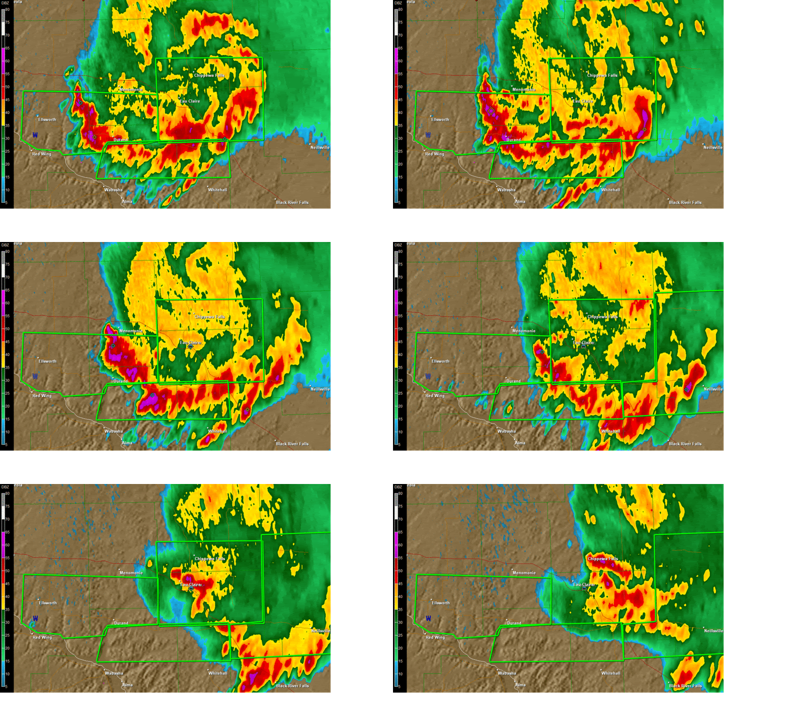
Heavy rains soaked parts of Western Wisconsin late Thursday night into early Friday morning. Rainfall totals as high as 6.5 inches were reported around the area, with that 6.5 inch amount coming in from the Durand area. The radar loop above shows the system as it moved through at pretty much a crawl, resembling the counter-clockwise motion you would see from a hurricane. While not a very large system in general, this cell made its presence known, forcing evacuations in the Town of Arkansas in Pepin County, as well as causing mudslides in the Maiden Rock area.
Above is a radar still taken shortly after 3am. You can see a pretty good swath of 3-5 inches of rain, as designated by the purple, and the heaviest amounts falling just to the west of the Durand area.
Heavy Rains Moving Through Chippewa Valley
Heavy rains have been moving through portions of Western Wisconsin tonight, and are in no real hurry to leave either. That has prompted the National Weather Service to issue Flash Flood Warnings for the areas with the green boxes around them in the graphic above. Storm reports have been coming in around the area, including mudslides in Pepin County, roads being washed out near Eau Claire, and some impressive rainfall totals. The cell that is causing this is not very large, however it has been moving ever so slowly through the area, with speeds as low at 10mph. Above is the radar indicated rainfall totals as of 1:15am. While radar tends to over-estimate, the area has still seen some impressive amounts.
Thursday, August 13, 2009
Slight Risk for Severe Weather
In their 11:30 CDT update, the Storm Prediction Center in Norman, OK has issued a Slight Risk (as designated by the green circle above) of severe weather for parts of Southeastern MN and West Central WI. The main threat would be large hail, with perhaps an isolated damaging wind gust. The threat for tornadoes is quite low, however should always be considered possible when dealing with severe weather. This doesn't appear to be an outbreak by any means, but people should keep an eye out for rapidly changing weather conditions.
Extreme Drought Continues
Even though most areas saw some rain this past weekend, the extreme drought for portions of Northwest Wisconsin continues. While most areas remain unchanged from last weeks drought monitor, a narrow band of what used to be a severe drought is now a moderate drought. That is thanks to some impressive rainfalls in this area from August 7th/8th, when these areas received between 2 and 6 inches of rainfall.
The outlook for rain in the extreme drought area is not too great over the next day or two, but things look promising Saturday night and through Sunday as a system slowly treks across the area. Sunday is also our next best chance of seeing some strong to severe weather (per NWS Hazardous Weather Outlook), so stay tuned for that.
Tuesday, August 11, 2009
Meteor Shower Tonight!
For all of you night owls out there, the annual Perseid meteor shower is expected to put on a good show this week for those willing to get up in the wee hours of the morning and wait patiently for the shooting stars.
In North America, the best time to watch will be between midnight to 5 a.m. on Wednesday, Aug. 12, with the best viewing time around the Chippewa Valley to be between 3 and 4 a.m., but late Tuesday night and also Wednesday night could prove fruitful, weather permitting.
The meteor shower is thanks to the earth passing through a debris trail of Comet Swift-Tuttle. Get away from the city lights, get a blanket or lawn chair, and enjoy the show. The only downside to an August showing is the brightness of the moon, which may wash out some of the smaller meteors.
First Major Hurricane Of 2009?
Subscribe to:
Posts (Atom)