Friday, August 14, 2009

Heavy Rains Sweep Through Western Wisconsin


Heavy rains soaked parts of Western Wisconsin late Thursday night into early Friday morning. Rainfall totals as high as 6.5 inches were reported around the area, with that 6.5 inch amount coming in from the Durand area. The radar loop above shows the system as it moved through at pretty much a crawl, resembling the counter-clockwise motion you would see from a hurricane. While not a very large system in general, this cell made its presence known, forcing evacuations in the Town of Arkansas in Pepin County, as well as causing mudslides in the Maiden Rock area.


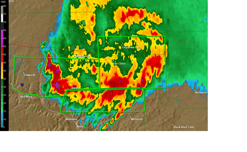
Above is a radar still taken shortly after 3am. You can see a pretty good swath of 3-5 inches of rain, as designated by the purple, and the heaviest amounts falling just to the west of the Durand area.

Heavy Rains Moving Through Chippewa Valley


Heavy rains have been moving through portions of Western Wisconsin tonight, and are in no real hurry to leave either. That has prompted the National Weather Service to issue Flash Flood Warnings for the areas with the green boxes around them in the graphic above. Storm reports have been coming in around the area, including mudslides in Pepin County, roads being washed out near Eau Claire, and some impressive rainfall totals. The cell that is causing this is not very large, however it has been moving ever so slowly through the area, with speeds as low at 10mph. Above is the radar indicated rainfall totals as of 1:15am. While radar tends to over-estimate, the area has still seen some impressive amounts.

Thursday, August 13, 2009

Slight Risk for Severe Weather


In their 11:30 CDT update, the Storm Prediction Center in Norman, OK has issued a Slight Risk (as designated by the green circle above) of severe weather for parts of Southeastern MN and West Central WI. The main threat would be large hail, with perhaps an isolated damaging wind gust. The threat for tornadoes is quite low, however should always be considered possible when dealing with severe weather. This doesn't appear to be an outbreak by any means, but people should keep an eye out for rapidly changing weather conditions.

Extreme Drought Continues


Even though most areas saw some rain this past weekend, the extreme drought for portions of Northwest Wisconsin continues. While most areas remain unchanged from last weeks drought monitor, a narrow band of what used to be a severe drought is now a moderate drought. That is thanks to some impressive rainfalls in this area from August 7th/8th, when these areas received between 2 and 6 inches of rainfall.

The outlook for rain in the extreme drought area is not too great over the next day or two, but things look promising Saturday night and through Sunday as a system slowly treks across the area. Sunday is also our next best chance of seeing some strong to severe weather (per NWS Hazardous Weather Outlook), so stay tuned for that.

Tuesday, August 11, 2009

Meteor Shower Tonight!


For all of you night owls out there, the annual Perseid meteor shower is expected to put on a good show this week for those willing to get up in the wee hours of the morning and wait patiently for the shooting stars.

In North America, the best time to watch will be between midnight to 5 a.m. on Wednesday, Aug. 12, with the best viewing time around the Chippewa Valley to be between 3 and 4 a.m., but late Tuesday night and also Wednesday night could prove fruitful, weather permitting.

The meteor shower is thanks to the earth passing through a debris trail of Comet Swift-Tuttle. Get away from the city lights, get a blanket or lawn chair, and enjoy the show. The only downside to an August showing is the brightness of the moon, which may wash out some of the smaller meteors.

First Major Hurricane Of 2009?


Long Range GFS model is showing what could be the first major hurricane of the season in the Atlantic. While this is still a good week and a half away, folks in the SE may want to keep an eye on it.